
 ©Historia National Geographic
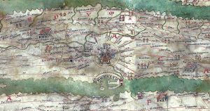
La Biblioteca Nacional de Viena alberga uno de los documentos más extraordinarios de la historia y evolución de la cartografía: el mapa de Peutinger. Este documento presenta casi siete metros de longitud e ilustra el mundo conocido a finales del Imperio Romano (siglo IV d.C).
Konrad Peutinger, humanista alemán dio el nombre a este mapa, fuente esencial para el estudio de la geografía antigua. Este rollo de pergamino de 33 centímetros de alto y aproximadamente 6,9 metros de largo, dividido en doce segmentos llegó a manos de Peutinger a principios del siglo XVI. Sin embargo, la copia que hoy se conserva es una primera copia medieval (siglo XIII) de un original romano. Este mapa es situado en el siglo IV debido a la presencia de Constantinopla, fundada en el año 330, por lo que este hecho nos indica que el mapa no puede ser anterior a esta fecha.
Cabe mencionar que la diferencia principal entre la cartografía romana y la griega es que la primera tuvo una finalidad práctica y, en la segunda, se priorizaba la orientación científica. De esta manera, siguiendo con la practicidad de los primeros, los romanos crearon los llamados “itinerarios”, documentos que registraban las principales arterias o estaciones de un territorio. Existían 2 tipos de itinerario:
- Los itineraria adnotata: listas vales que enumeraban las principales estaciones y distancias en millas. El más conocido es el Itinerario de Antonino (siglo III), aunque también destacan los Vasos de Vicarello o el Anónimo de Ravena.
- Los itineraria picta: representaciones gráficas con especial hincapié en la red viaria, como la Tabula de Peutinger.
El mapa de Peutinger comienza en los Pirineos y termina en la península de la India y la isla de Taprobane (Sri Lanka). Abarca así, la “ecúmene”: la tierra habitada conocida a excepción de la representación de la península Ibérica, fragmento que se perdió y finalmente fue reconstruido por Konrad Miller en 1898. En la Tabula aparecen ríos, mares, accidentes geográficos y ciudades. También se pueden observar centros religiosos, lugares destinados al descanso, al cambio de caballería; es decir, toda aquella información que era imprescindible a la hora de emprender un viaje. Llama la atención también, la representación de los puertos comerciales en el Mediterráneo, como puede ser el de Ostia, principal vía de entrada a Roma por mar, así como otros centros termales. Toda esta información permite ver que el mapa no fue creado con fines militares, sino más bien, particulares.
El mapa también incluye notas que permiten explicar la importancia de algunos puntos, como ocurre en la zona de Sinaí: “el desierto por el que durante cuarenta años erraron los hijos de Israel guiados por Moisés”. A su vez, la ciudad de Roma aparece representada con una figura sentada en un trono, lo que permite entrever que debió de ocupar, en ese momento, el centro neurálgico.
Por último, como mapa viario, las vías de comunicación están marcadas en rojo y representan aproximadamente 70000 millas romanas. Sin embargo, no se pueden establecer distancias viarias reales ni calcular un espacio geográfico. Este mapa no presenta ningún tipo de proyección ya que, la tierra viene representada a través de una línea horizontal, siguiendo la visión del viajero. Es por eso que, no se puede aplicar una escala constante, ya que las dimensiones este-oeste quedan ensanchadas y las norte-sur reducidas y estrechadas, modificando los puntos cardinales. Este fenómeno explica que el río Nilo aparece representado fluyendo de oeste a este y no de sur a norte.
La red viaria de los romanos era una guía fundamental para determinar su ubicación. Para investigadores actuales, en cambio, resulta una guía imprescindible para conocer y comprender la Antigüedad.
Desde OceanArt Project, se pretende concienciar sobre la importancia del patrimonio cartográfico, mostrando especial interés, en aquellas rutas relacionadas con el mundo marino. Este patrimonio, material e inmaterial a su vez, es una de las áreas de investigación que cuenta con la participación de la Fundación Giménez Lorente, ubicada en la Universitat Poltècnica de València y que cuenta con una gran colección de documentos cartográficos.
__
PEUTINGER’S MAP
The National Library of Vienna houses one of the most extraordinary documents in the history and evolution of cartography: the Peutinger map. This document is almost seven meters long and illustrates the known world at the end of the Roman Empire (4th century AD).
Konrad Peutinger, a German humanist, gave his name to this map, an essential source for the study of ancient geography. This parchment roll, 33 centimeters high and approximately 6.9 meters long, divided into twelve segments, came into Peutinger’s hands in the early 16th century. However, the copy preserved today is an early medieval copy (13th century) of a Roman original. This map is placed in the fourth century due to the presence of Constantinople, founded in 330, so this fact indicates that the map cannot be earlier than this date.
It is worth mentioning that the main difference between Roman and Greek cartography is that the former had a practical purpose and, in the latter, the scientific orientation was prioritized. Thus, following the practicality of the former, the Romans created the so-called “itineraries”, documents that recorded the main arteries or stations of a territory. There were 2 types of itinerary:
1. The itineraria adnotata: voucher lists that listed the main stations and distances in miles. The best known is the Itinerary of Antoninus (3rd century), although the Vicarello Vases or the Anonymous of Ravenna also stand out.
2. The itineraria picta: graphic representations with special emphasis on the road network, such as Peutinger’s Tabula.
Peutinger’s map begins in the Pyrenees and ends in the Indian peninsula and the island of Taprobane (Sri Lanka). It thus covers the “ecumene”: the known inhabited land except for the representation of the Iberian Peninsula, a fragment that was lost and finally reconstructed by Konrad Miller in 1898. In the Tabula appear rivers, seas, geographical features and cities. Religious centers, places for resting and changing horses can also be seen; in other words, all the information that was essential when embarking on a journey. The representation of the commercial ports in the Mediterranean, such as Ostia, the main entrance to Rome by sea, as well as other thermal centers, is also noteworthy. All this information shows that the map was not created for military purposes, but rather for private purposes.
The map also includes notes explaining the importance of some points, such as the area of Sinai: “the desert through which the children of Israel wandered for forty years under the guidance of Moses”. In turn, the city of Rome is represented by a figure seated on a throne, which suggests that it must have occupied, at that time, the nerve center.
Finally, as a road map, the roads are marked in red and represent approximately 70000 Roman miles. However, it is not possible to establish real road distances or to calculate a geographical space. This map does not present any type of projection since the land is represented by a horizontal line, following the vision of the traveler. For this reason, a constant scale cannot be applied, since the east-west dimensions are widened and the north-south dimensions are reduced and narrowed, modifying the cardinal points. This phenomenon explains why the Nile River is represented flowing from west to east and not from south to north.
The Roman road network was a fundamental guide to determine its location. For current researchers, however, it is an essential guide to know and understand Antiquity.
The OceanArt Project aims to raise awareness of the importance of cartographic heritage, showing special interest in those routes related to the marine world. This heritage, both tangible and intangible, is one of the areas of research with the participation of the Giménez Lorente Foundation, located at the Polytechnic University of Valencia, which has a large collection of cartographic documents.
__